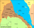
Eritrea
Facts & Figures
-
President: Isaias Afwerki (1993)
Total area: 46,842 sq mi (121,320 sq km)
Population (2014 est.): 6,380,803 (growth rate: 2.3%); birth rate: 30.69/1000; infant mortality rate: 38.44/1000; life expectancy: 63.51
Capital and largest city (2011 est.): Asmara, 712,000
Other large cities: the ports of Massawa, 30,700; and Assab, 56,300
Monetary unit: Nakfa
Languages: Tigrinya (official), Arabic (official), English (official), Tigre, Kunama, Afar, other Cushitic languages
Ethnicity/race: nine recognized ethnic groups: Tigrinya 55%, Tigre 30%, Saho 4%, Kunama 2%, Rashaida 2%, Bilen 2%, other (Afar, Beni Amir, Nera) 5% (2010 est.)
National Holiday: Independence Day, May 24
Religions: Muslim, Coptic Christian, Roman Catholic, Protestant
Literacy rate: 68.9% (2011 est.)
Economic summary: GDP/PPP (2013 est.): $4.717 billion; per capita $1,200 . Real growth rate: 7%. Inflation: 13%. Unemployment: n.a. Arable land: 5.87%. Agriculture: sorghum, lentils, vegetables, corn, cotton, tobacco, coffee, sisal; livestock, goats; fish. Labor force: 2.955 billion (2012); agriculture 80%, industry and services 20%. Industries: food processing, beverages, clothing and textiles, salt, cement, commercial ship repair. Natural resources: gold, potash, zinc, copper, salt, possibly oil and natural gas, fish. Exports: $496.2 million (2013 est.): livestock, sorghum, textiles, food, small manufactures. Imports: $1.027 billion (2013 est.): machinery, petroleum products, food, manufactured goods. Major trading partners: Australia, France, Malaysia, Italy, Sudan, Saudi Arabia, Jordan, Germany, China, Brazil, U.S., Turkey (2006).
Communications: Telephones: main lines in use: 60,000 (2012); mobile cellular: 305,300 (2012). Broadcast media: government controls broadcast media with private ownership prohibited; 1 state-owned TV station; state-owned radio operates 2 networks; purchases of satellite dishes and subscriptions to international broadcast media are permitted (2007). Internet hosts: 701 (2012). Internet users: 200,000 (2008).
Transportation: Railways: total: 306 km (2008). Highways: total: 4,010 km; paved: 874 km; unpaved: 3,136 km (2000 est.). Ports and harbors: Assab, Massawa. Airports: 13 (2013).
International disputes: Eritrea and Ethiopia agreed to abide by 2002 Ethiopia-Eritrea Boundary Commission's (EEBC) delimitation decision, but neither party responded to the revised line detailed in the November 2006 EEBC Demarcation Statement; Sudan accuses Eritrea of supporting eastern Sudanese rebel groups; in 2008 Eritrean troops moved across the border on Ras Doumera peninsula and occupied Doumera Island with undefined sovereignty in the Red Sea.