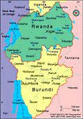
Burundi
Facts & Figures

-
Republic of Burundi
President: Pierre Nkurunziza (2005)
Land area: 9,903 sq mi (25,649 sq km); total area: 10,745 sq mi (27,830 sq km)
Population (2014 est.): 10,395,931 (growth rate: 3.28%); birth rate: 42.33/1000; infant mortality rate: 63.44/1000; life expectancy: 59.55
Capital and largest city (2011 est.): Bujumbura, 605,000
Other large city: Gitega, 45,700
Monetary unit: Burundi franc
National name: Republika y'u Burundi
Languages: Kirundi 29.7% (official), Kirundi and other language 9.1%, French (official) and French and other language 0.3%, Swahili and Swahili and other language 0.2% (along Lake Tanganyika and in the Bujumbura area), English and English and other language 0.06%, more than 2 languages 3.7%, unspecified 56.9% (2008 est.)
Ethnicity/race: Hutu (Bantu) 85%, Tutsi (Hamitic) 14%, Twa (Pygmy) 1%, Europeans 3,000, South Asians 2,000
National Holiday: Independence Day, July 1
Religions: Catholic 62.1%, Protestant 23.9% (includes Adventist 2.3% and other Protestant 21.6%), Muslim 2.5%, other 3.6%, unspecified 7.9% (2008 est.)
Literacy rate: 67.2% (2010 est.)
Economic summary: GDP/PPP (2013 est.): $5.75 billion; per capita $600. Real growth rate: 4.5%. Inflation: 9.3%. Unemployment: n.a. Arable land: 33.06%. Agriculture: coffee, cotton, tea, corn, sorghum, sweet potatoes, bananas, manioc (tapioca); beef, milk, hides. Labor force: 4.245 million (2007); agriculture 93.6%, industry 2.3%, services 4.1% (2002 est.). Industries: light consumer goods such as blankets, shoes, soap; assembly of imported components; public works construction; food processing. Natural resources: nickel, uranium, rare earth oxides, peat, cobalt, copper, platinum (not yet exploited), vanadium, arable land, hydropower, niobium, tantalum, gold, tin, tungsten, kaolin, limestone. Exports: $122.8 million (2013 est.): coffee, tea, sugar, cotton, hides. Imports: $867.2 million (2013 est.): capital goods, petroleum products, foodstuffs. Major trading partners: Belgium, Pakistan, U.S., Rwanda, U.K., Democratic Republic of the Congo, China, Egypt, India, Kenya, Tanzania, Italy, Uganda, Zambia (2012).
Communications: Telephones: main lines in use: 17,400 (2012); mobile cellular: 2.247 million (2012). Broadcast media: state-controlled La Radiodiffusion et Television Nationale de Burundi (RTNB) operates the lone TV station and the only national radio network; about 10 privately owned radio stations; transmissions of several international broadcasters are available in Bujumbura (2007). Internet hosts: 229 (2011). Internet users: 157,800 (2009).
Transportation: Railways: 0 km. Highways: total: 12,322 km; paved: 1,286 (2004 est.). Waterways: mainly on Lake Tanganyika (2011). Ports and harbors: Bujumbura. Airports: 7 (2013).
International disputes: Burundi and Rwanda dispute two sq km (0.8 sq mi) of Sabanerwa, a farmed area in the Rukurazi Valley where the Akanyaru/Kanyaru River shifted its course southward after heavy rains in 1965; cross-border conflicts persist among Tutsi, Hutu, other ethnic groups, associated political rebels, armed gangs, and various government forces in the Great Lakes region.

