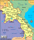
Laos
Facts & Figures

-
President: Choummaly Sayasone (2006)
Prime Minister: Thongsing Thammavong (2010)
Land area: 89,112 sq mi (230,800 sq km); total area: 91,428 sq mi (236,800 sq km)
Population (2014 est.): 6,803,699 (growth rate: 1.59%); birth rate: 24.76/1000; infant mortality rate: 54.53/1000; life expectancy: 63.51
Capital and largest city (2011 est.): Vientiane, 810,000
Monetary unit: New Kip
National name: Sathalanalat Paxathipatai Paxaxon Lao
Languages: Lao (official), French, English, various ethnic languages
Ethnicity/race: Lao 55%, Khmou 11%, Hmong 8%, other (over 100 minor ethnic groups) 26% (2005 census)
Religions: Buddhist 67%, Christian 1.5%, other and unspecified 31.5% (2005 census)
National Holiday: Republic Day, December 2
Literacy rate: 72.7% (2005 est.)
Economic summary: GDP/PPP (2013 est.): $20.78 billion; per capita $3,100. Real growth rate: 8.3%. Inflation: 6.5%. Unemployment: 1.9% . Arable land: 5.91%. Agriculture: sweet potatoes, vegetables, corn, coffee, sugarcane, tobacco, cotton, tea, peanuts, rice; water buffalo, pigs, cattle, poultry. Labor force: 3.373 million (2013 est.); agriculture 75.1%, industry and services NA (2001 est.). Industries: copper, tin, and gypsum mining; timber, electric power, agricultural processing, construction, garments, tourism, cement. Natural resources: timber, hydropower, gypsum, tin, gold, gemstones. Exports: $2.313 billion (2011 est.): garments, wood products, coffee, electricity, tin. Imports: $3.238 billion (2013 est.): machinery and equipment, vehicles, fuel, consumer goods. Major trading partners: Thailand, Vietnam, China, (2011) .
Communications: Telephones: main lines in use: 112,000 (2012); mobile cellular: 6.492 (2012). Broadcast media: 6 TV stations operating out of Vientiane - 3 government-operated and the others commercial; 17 provincial stations operating with nearly all programming relayed via satellite from the government-operated stations in Vientiane; Chinese and Vietnamese programming relayed via satellite from Lao National TV; broadcasts available from stations in Thailand and Vietnam in border areas; multi-channel satellite and cable TV systems provide access to a wide range of foreign stations; state-controlled radio with state-operated Lao National Radio (LNR) broadcasting on 5 frequencies - 1 AM, 1 SW, and 3 FM; LNR's AM and FM programs are relayed via satellite constituting a large part of the programming schedules of the provincial radio stations; Thai radio broadcasts available in border areas and transmissions of multiple international broadcasters are also accessible (2012). Internet Service Providers (ISPs): 1,532 (2012). Internet users: 300,000 (2009).
Transportation: Railways: 0 km. Highways: total: 39,568 km; paved: 530 km; unpaved: 39,038 km (2007 est.). Waterways: about 4,600 km, primarily Mekong and tributaries; 2,897 additional km are sectionally navigable by craft drawing less than 0.5 m. Ports and harbors: none. Airports: 41 (2013).
International disputes: southeast Asian states have enhanced border surveillance to check the spread of avian flu; talks continue on completion of demarcation with Thailand but disputes remain over islands in the Mekong River; concern among Mekong River Commission members that China's construction of dams on the Mekong River and its tributaries will affect water levels; Cambodia and Vietnam are concerned about Laos' extensive upstream dam construction.

