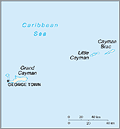
The Caymans consist of three islands—Grand Cayman (76 sq mi; 197 sq km), Cayman Brac (22 sq mi; 57 sq km), and Little Cayman (20 sq mi; 52 sq km)—situated about 180 mi (290 km) northwest of Jamaica. They were dependencies of Jamaica until 1959, when they became a unit territory within the Federation of the West Indies. In 1962, upon the dissolution of the federation, the Cayman Islands became a British dependency, and a new constitution approved in 1972 provided for a greater degree of autonomy. Tourism and finance are the Cayman Islands' major industries. For a time, the Cayman Islands were blacklisted by the Paris-based Financial Action Task Force (FATF) for its allegedly loose policy concerning money laundering. It was removed from the list in 2001.
In 2009, the position of Premier of the Cayman Islands was established. Before then the role was known as Leader of Government Business. The first Premier was McKeeva Bush followed by Julianna O'Connor-Connolly, who served from December 2012 through May 2013. On May 29, 2013, Alden McLaughlin took office. McLaughlin, a member of the People's Progressive Movement, has served in the Legislative Assembly of the Cayman Islands since 2000.


