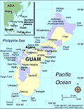
Guam is the largest and southernmost island in the Marianas Archipelago. The island is divided into a northern coralline limestone plateau and a southern chain of volcanic hills. Today Guam is an unincorporated, organized territory of the United States. The people of Guam have been U.S. citizens since 1950. They have been represented in the U.S. Congress since 1973 by a nonvoting delegate, but they do not participate in presidential elections. The executive branch includes a popularly elected governor, who serves a four-year term. The legislative branch is a 21-member unicameral legislature whose members are elected every two years.
Guam was probably explored by the Portuguese navigator Ferdinand Magellan (sailing for Spain) in 1521. The island was formally claimed by Spain in 1565, and its people were forced into submission and conversion to Roman Catholicism beginning in 1668. After the Spanish-American War of 1898, Spain ceded Guam to the United States. From 1899 to 1949, the U.S. Navy administered Guam, except during the Japanese occupation from 1941–1944. Guam was liberated by American military forces in the summer of 1944. Guam's economy is based on tourism and U.S. military spending (U.S. naval and air force bases occupy one-third of the land on Guam).

