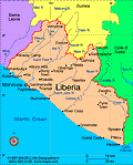
Liberia
Facts & Figures

-
President: Ellen Johnson-Sirleaf (2006)
Land area: 37,189 sq mi (96,320 sq km); total area: 43,000 sq mi (111,370 sq km)
Population (2014 est.): 4,092,310 (growth rate: 2.52%); birth rate: 35.07/1000; infant mortality rate: 69.19/1000; life expectancy: 58.21
Capital and largest city (2011 est.): Monrovia, 750,000
Monetary unit: Liberian dollar
Languages: English 20% (official), some 20 ethnic group languages few of which can be written or used in correspondence
Ethnicity/race: Kpelle 20.3%, Bassa 13.4%, Grebo 10%, Gio 8%, Mano 7.9%, Kru 6%, Lorma 5.1%, Kissi 4.8%, Gola 4.4%, other 20.1% (2008 Census)
Religions: Christian 85.6%, Muslim 12.2%, Traditional 0.6%, other 0.2%, none 1.4% (2008 Census)
National Holiday: Independence Day, July 26
Literacy rate: 60.8% (2010 est.)
Economic summary: GDP/PPP (2013 est.): $2.898 billion; per capita $700. Real growth rate: 8.1%. Inflation: 5.2%. Unemployment: 85% (2003 est.). Arable land: 4.04%. Agriculture: rubber, coffee, cocoa, rice, cassava (tapioca), palm oil, sugarcane, bananas; sheep, goats; timber. Labor force: 1.372 million (2007): agriculture 70%, industry 8%, services 22% (2000 est.). Industries: rubber processing, palm oil processing, timber, diamonds. Natural resources: iron ore, timber, diamonds, gold, hydropower. Exports: $929.8 million (2013 est.): rubber, timber, iron, diamonds, cocoa, coffee. Imports: $2.457 billion (2013 est.): fuels, chemicals, machinery, transportation equipment, manufactured goods; foodstuffs. Major trading partners: South Korea, Japan, China, Spain, Algeria, Thailand, Malaysia, France, Singapore (2012).
Communications: Telephones: main lines in use: 3,200 (2011); mobile cellular: 2.394 million (2012). Broadcast media: 3 private TV stations; satellite TV service available; 1 state-owned radio station; about 15 independent radio stations broadcasting in Monrovia, with another 25 local stations operating in other areas; transmissions of 2 international broadcasters are available (2007). Internet Service Providers (ISPs): 7 (2012). Internet users: 20,000 (2009).
Transportation: Railways: total: 429 km; note: most sections of the railways were inoperable because of damage suffered during the civil wars from 1980 to 2003, but many are being rebuilt (2008). Highways: total: 10,600 km; paved: 657 km; unpaved: 9,943 km (2000 est.). Ports and harbors: Buchanan, Monrovia. Airports: 28 (2013).
International disputes: although civil unrest continues to abate with the assistance of 6,500 UN Mission in Liberia peacekeepers, as of January 2013, Liberian refugees still remain in Guinea, Cote d'Ivoire, Sierra Leone, and Ghana; Liberia, in turn, shelters refugees fleeing turmoil in Cote d'Ivoire; despite the presence of over 9,000 UN forces in Cote d'Ivoire since 2004, ethnic conflict continues to spread into neighboring states who can no longer send their migrant workers to Ivorian cocoa plantations; UN sanctions ban Liberia from exporting diamonds and timber.

